Maps and Monsters: Why and how did sea monsters find their way into the art of cartography?
Written and researched by
Dr Maeve Sisi Silvia Mulligan Nolan
(PhD Obtained in Art History and Archaeology of Africa and Asia, School of Oriental and African Studies, University of London)
“The water was infested with all kinds of reptiles. There were writhing sea-dragons and monsters slouching on slopes by the cliff, serpents and wild things such as those that often surface at dawn to roam the sail-road and doom the voyage.”
(Heaney, 2000, p.20, Lines 1425-1430).
Introduction:
This quote from Beowulf (975-1025) is representative of the fears that mankind held for centuries regarding the oceans. Such long-held trepidation regarding water make it no surprise that images of sea monsters found their way onto some of the earliest maps mankind created.
I will approach this subject by focusing on Olaus Magnus’(1490-1557) highly detailed illustrated map (1539) of Scandinavia. Chat Van Duzer (2013), an expert in the field of cartography and sea monsters therein, describes Magnus’ map as the most important map with monsters of the Renaissance Period (1450-1650).[1] I will use Magnus’ map as an anchor point from which I can explore the genre as a whole. I will begin by looking at the period in which the map was created and reasons why such maps with monsters exist. I will then look at Olaus Magnus and the reasons for and significance of his map and its monsters.
The Renaissance (1450-1650):
Europe during the Renaissance was a time of extraordinary fervour in the realms of art and science. This was a time of tremendous excitement and querying about what the world could possibly contain[2] and as a result this, together with technological advancements, European sailors made ever greater exploration into the world by land and sea with significant support from the Catholic Church. Cartography was an ideal means of delineating new knowledge about the world[3] and consequently for ensuring the success of these ventures. Paper and copper engraving allowed for maps to be obtained widely and relatively cheaply by those who were not trained cartographers or sea-faring men, thereby contributing to a wider learned Renaissance culture. The increase in study of and interest in cartography allowed for ever more accurate maps and cartographic innovation.[4]
During the Renaissance, maps found a new home beyond the cabins of dark treacherous ships, and into the homes of the wealthy and scholarly. Maps were no longer solely navigational tools, they also became symbols of power. Through a map, a King could survey and present the details of his kingdom from his throne,[5] a tradesman show off his economic empire or a wealthy man demonstrate his intellectual prowess through the display of a map in his parlour.[6] The use of maps for purposes other than seafaring led to a demand for ever more ornately decorated maps, and it was these that were likely to contain sea creatures.
The inclusion of sea creatures on Renaissance maps were uncommon,[7] rather they were costly additions, included at the behest of the map’s patron.[8] From a purely economic standpoint, the visual interest and beauty that sea creatures brought to a map aided in securing future commissions. So much so that some cartographic studios employed specialists in depicting sea creatures.[9]
Sea Monsters:
“Who did not see monsters, did not navigate.”[10]
Humans have an innate drive to understand what they do not already know and explore and “conquer” those places they are not privy to, man’s exploration of the oceans exemplify this. Humans are designed to traverse the land, not the sea. We cannot breathe underwater, move quickly beneath its waves, nor do we have eyes accustomed to see through water with clarity, yet we continue to attempt to tame it.
The ocean has held sway over the imagination of mankind for centuries, demonstrated by the huge amount of art and literature it has inspired. The vastness of the ocean makes us feel small and insignificant, and our lack of real understanding of its depths captivates us and provides a world for our imaginations to run wild in. Man’s relationship with the sea was built upon a long lineage of human thought on the subject, drawn from multiple time periods, religions, peoples and regions. For example, during antiquity the oceans were regarded as the edge of the known world:
“…where the divine, the human and the animal mix one with each other, where myth and reality were inextricably blending together… And so, where humans could not reach up with their sight, the imagination found a prosperous land to give birth to monsters, for they are literally the product of the environment that hosts them.”[11]
According to Bobaru (2022), during the Mediaeval period the oceans retained their status as a terrifying monstrous dwelling. However, as maritime studies and exploration expanded, terror transformed to curiosity.[12] This does not mean that people stopped believing that the oceans contained monsters, to many people of the 16th Century and earlier these creatures were still a visceral threat.[13] Such monsters were fathomed from centuries of belief, developed in an attempt to explain the unexplainable and to warn communities of the dangers that might befall them if straying too deep, or too close to the water’s edge. Be that in the form of the West African Mami-Wata (figure 1), Australian Bunyip (figure 2) or a plethora of other aquatic creatures, these beings represent the history of mankind’s understanding and fears of water, as well as their encounters with water dwelling animals and phenomena.[14] It is therefore, no wonder that such beings found their way onto early maps.

Figure 1, ‘Sculpture of the African water deity Mami Wata from Nigeria (Igbo)’, 1950s, Minneapolis Institute of Art.

Figure 2, H.J. Ford, ‘The Bunyip’, Published in 1904 as part of The Brown Fairy Book.
Bobaru (2022) proffers the concept that the ocean and its sea monsters were truly brought to life in mankind’s imagination at the end of the 15th century, when the first transatlantic sea voyages took place. At this time people were not only drawing knowledge about the oceans from pagan myth, antiquity and biblical texts but also upon what knowledge had been newly acquired from people in foreign lands.[15] [16]
Understandably, sailors were one of the main sources for information about the ocean during this time. Their accounts of what they saw at sea may well have been hammed-up, invented for the purpose of acquiring money or status, or based on real experiences they had at sea. For example, Christopher Columbus (1451-1506) claimed that, during his 1492 voyage, he saw a mermaid. In reality his account provided the first written record of manatees in North America.[17] He wrote that:
“…they were not so beautiful as they are described, for in a way, their faces resembled a man’s face.” [18]
Columbus also wrote of having fished:
“A fish (…) that seemed to be a pig covered with fish scales.” [19]
There was a long-held theory, going back to at least the first century and Pliny the Elder (d.79AD), that professed that every land animal has an equivalent in the ocean:
“…so the vulgar notion may be true, that anything which is produced in any other department of Nature, may be found in the sea as well.”[20]
There were thought to be sea dogs, chickens, pigs and even a sea hare named Lepus Marius,[21] this theory continued to be espoused into the 16th century.[22]
One of the most interesting theories about sea monsters, possibly linked to Pliny’s theory, is Bernard Huevelmans and Gilbert Lascaut’s claim that “language poverty” was the reason for the verbal and pictorial descriptions of sea monsters. In describing the unknown people utilised what they knew.[23] For example, a puffer fish could be described and drawn as a sea porcupine.[24]
Sea-creatures appeared on maps for various reasons, for example as metaphorical alerts to danger outside of the monstrous.[25] Bobaru (2022) suggests that their presence signalled the danger of the sea and its bestial character, and that in a sense the ocean itself was viewed as a monster[26] capable of consuming your body.
Regardless of one’s faith, such a notion is terrifying, but for a Catholic, the dominant religion of Europe during the Renaissance Period, the loss of the physical body was grievous. Renaissance maps were made in a Christian culture. For their makers and users the oceans had a particularly perilous association: a layer of demons (figure 3).[27] This is clear in one of the most well-known biblical stories, The Great Flood:
“All the fountains of the great abyss[28] burst forth and the floodgates of the sky were opened….Higher and higher on the earth the waters swelled, until all the highest mountains under the heavens were submerged. The waters swelled fifteen cubits higher than the submerged mountains. All creatures that moved on earth perished: birds, tame animals, wild animals, and all that teemed on the earth, as well as all humankind. Everything on dry land with the breath of life in its nostrils died.”[29]
The ocean was seen by many Abrahamic Religons, during and before the Renaissance Periods, as a vestige of the catastrophe of the flood:
“…a liquid space without landmarks, a picture of the in- finite, disorder, chaos, and consequently a landmark for monsters.”[30]
Illustrated maps made the existence of sea monsters all the more visceral. They allowed one to see what would normally be hidden beneath the waves, a world that for many was considered demonic.

Figure 3, Andreas Bianco, ‘A two-tailed siren and also two winged dragons in a watery abyss in the southern ocean’, Mappamundi, 1436, Venice Biblioteca Nazionale Marcicana.
In quite the opposite vein of thought, Brownstein suggests that sea monsters represented the rich vitality of the oceans[31] and the riches that could be obtained by navigating and staking claim over them. Van Duzer (2013) proffers the idea that the placement of these creatures on maps could also be purely decorative or used to conceal gaps in knowledge,[32] as monsters were often located in poorly understood areas.[33] A sea monster’s presence on a map is not always due to one thing or another but can simultaneously encompass many of these hypotheses,[34] depending on the whims of the person who produced or paid for the map, as well as the particular beliefs of its viewer. One thing seems to be certain is that the decoration of these maps represents an interest in understanding the world, its workings and its contents.
Rev.Fr. Magnus Map:
Olof Mansson (Latin translation: Olaus Magnus) (1490-1557) was born in Linkoping, Sweden. In 1517 he completed his theological training and embarked on a career in the Catholic Priesthood.[35] During his life in Sweden Rev.Fr. Magnus travelled extensively across the lands and through the seas of Scandinavia.[36] During his travels he collected classical texts, folklore stories and eyewitness accounts of the particulars and peculiarities of the region.[37] One should also recognise that throughout his time in Scandinavia Rev.Fr. Magnus would have likely accumulated knowledge of the beliefs and stories of Scandinavia’s Viking past, within which the ocean and travel across it were of great cultural significance.
In 1523 Rev.Fr. Magnus’ brother, Johannes Magnus (1488-1544)[38], was installed as Archbishop of Sweden, however, by 1526 the Most Reverend Archbishop Johannes Magnus[39] lost favour with the king, due to his discontent with the King’s Lutheran leanings. As a result the King sent Reverend Archbishop Johannes Magnus to Russia as a diplomat. In the same year Rev.Fr. Magnus travelled to Rome to explain the situation to the Vatican. A few years later in 1527, the Swedish King Gustav I converted to Lutheranism ushering in the Swedish Reformation.[40] Rev.Fr. Magnus and his brother were no longer able to return home and lived the rest of their life in exile, their family assets were seized and they lost state funds from Sweden.[41] To be locked out of your homeland and for that homeland to have rejected the faith to which you had dedicated your life must have been deeply disturbing.
As a result of this upheaval, the two brothers accept charity from the Archbishop of Poland and the Danzig’s (Gdansk) city council. They moved to the port city of Danzig,[42] which proved fruitful for Rev.Fr. Magnus. Here he could meet with Baltic scholars and seafarers, thereby gaining further knowledge of first-hand experience of the oceans as well as the most recent academic musings and discoveries. One of the scholars he befriended was the cartographer Bernard Wapowski (1450-1535) the father of Polish cartography,[43] who shared his knowledge of the region with Rev.Fr. Magnus.[44] [45]
In 1537 Rev.Fr. Magnus left Poland for Venice, the mapmaking hub of Europe.[46] Whilst there he published the Carta Marina (map of the sea) (figure 4), published in 1539.[47] The map took twelve years to create and when it was published it was the largest and most accurate map of Scandinavia.[48] Rev.Fr. Magnus had a right of publication from the Venetian Dogo Pietro Lando and the imprimatur of Pope Paul III, evidencing the map’s importance was recognised by the Vatican,[49] one of the most powerful and influential institutions in the world.

Figure 4, Olaus Magnus’ Map of Scandinavia, 1539, James Ford Bell Library, University of Minnesota.
The map was hand printed using nine woodblocks and nine sheets of handmade paper. In total the map measured 4 feet by 5 feet.[50] The process of production of such a large and highly detailed map was apt to mistakes and consequently costly, requiring 440 ducats (approximately £42,000 in modern money by one estimate) to be printed.[51] It is therefore no surprise that only two original versions of this map survive today[52].[53]
As was the tradition of the time, Rev.Fr. Magnus’ map functioned not only as a map but as an illustrated encyclopaedia. The map is filled with illustrations of the terrain, history and daily life of Scandinavia’s people and animals,[54] as well as oceans with monstrous creatures and brave ships cutting a path through perilous waters.[55] Rev.Fr. Magnus simultaneously published an accompanying sixteen-page pamphlet with his map in Italian, titled Opera Breve (Brief Work), and in German, Ain Kurze Auslegung und Verklerung der Neuuen Mappan (A Brief Interpretation and Explanation of The New Map).[56] This contained further information on Scandinavia’s geographical aspects as well as elaborations on many of the nine hundred places mentioned in the map.[57]
The map is not only accompanied by text, but contains text. Each sea creature is identified with its name and description in Latin text in the map’s key,[58] whilst the kingdoms of the land are shown with their coat of arms and a biblical quote. Catholic kingdoms are accompanied by quotes of praise, whilst Protestant kingdoms are provided with quotes of condemnation. Some of the monstrous sea creatures reflect anti-protestant feelings. For example a sea swine off the Northwest of the Tile Islands was described by Rev.Fr. Magnus thus:
“For it had a hog’s head, and a quarter of a circle, like the moon, in the hinder part of its head, four feet like a dragons, two eyes on both sides of its Loyns, and a third in his belly inkling towards his Navel; behind he had a forked-tail, like to other fish commonly.”[59]
He claimed the creature (figure 5) had been sighted in the waters off Germany in 1537, the same year in which the Reformation was completed in Denmark and Norway.[60] Rev.Fr. Magnus wrote that:
“There also roam very many monsters which have devised for themselves new laws of the Christian faith and religion.”[61]

Figure 5, Sea Pig detail from Olaus Magnus’ Map of Scandinavia, 1539, James Ford Bell Library, University of Minnesota.
This same boar is claimed by Rev.Fr. Magnus to have been exhibited in Antwerp. The source for this information and its image is likely from a pamphlet published in Rome in 1537. Such insight could be an example of how Rev.Fr. Magnus incorporated the latest scientific information about sea monsters into his map.[62][63] [64]
Today it might seem strange that a man of god would have included in his map creatures that today we would cast into the realms of fantasy and possibly sacrilege.[65] However, as mentioned earlier, within religious texts there are various descriptions of creatures and daemons residing in the oceans. For example, in Psalm 104:25-26:
“In wisdom you have made them all the earth is full of your creatures.
There is the sea, great and wide!
It teems with countless beings,
living both large and small.
There ships ply their course and Leviathan, whom you formed to play with.”[66]
Rev.Fr. Magnus’ map features a leviathan (figure 6). His depiction of this creature is reminiscent of a giant angry seahorse, with its red mouth open seemingly making a blood curdling call of anguish. There is ready use of red, the colour of blood, in Rev.Fr. Magnus’ rendering of his sea monsters’ mouths, possibly a signal of their ferocious nature. Leviathans are thought of as being of terrifyingly vast proportions. Magnus shows this to the viewer by only presenting us with the leviathan’s colossal head,[67] forcing the viewer to imagine the vastness of the body to which such an enormous skull is attached. Not being shown something allows the viewer’s imagination to run wild, often in a much more creative and visceral manner then an illustration could.

Figure 6, Olaus Magnus’ Map of Scandinavia, 1539, ‘Leviathan’, James Ford Bell Library, University of Minnesota.
In 1555 Rev.Fr. Magnus wrote another reference book, it contained even more detailed information about the people and nature of Scandinavia depicted in the map. This book was titled Historia de Gentibus Septentrionalibus (A History of Northern Peoples),[68] and was written in Latin and illustrated with 481 woodcut illustrations.[69] This publication is considered to be vital for understanding the map in its fullest.[70] Rev.Fr. Magnus describes the work as containing an account of Northern peoples’:
“…different positions, customs, habits, ways of life, superstitions, methods of instruction, activities, government, food, wars, buildings, implements, metal mines and marvels, together with almost all the living creatures that dwell in the North and their characteristics.”[71]
The fact that it was translated into Italian (1565), German (1567), English (1658) and Dutch (1665) is testament to its popularity. People outside of Scandinavia knew little of the region and such a text and map contributed to knowledge about this overlooked region.[72] Many of the regions that the map depicted had converted to Protestantism, and Catholic scholars were not welcome to study there nor to make maps in person. It is therefore not bizarre to suggest that a map that Robert Karrow described as being:
“… not just geography but history and ethnography as well.”[73]
may have been looked over and found useful by those Catholic representatives, sent illegally by the Vatican to places like Sweden in order to educate its people to return to Catholicism.[74]
As was the precedent for the cartographic industry, Rev.Fr. Magnus’ map drew upon those maps that came before it, as well as classical writings such as the Ancient Greek writings of Ptolemy’s Geographia or the Physiologus. He also drew on various bestiaries, for example his illustration of a sea cow (Vacca Marina) in the waters off the West coast of Norway likely comes from the Hortus Sanitatis[75].[76]
The ‘Whale Island’ was a well-known concept (figure 7). For example, it was also written about in various Icelandic texts, including the Icelandic saga of Orvar-Odds (old Norse Ovar-Oddr) (13th century).[77] These stories are believed to have inspired the Icelandic belief in the; Hafgufa or “sea steam” and Lyngbaker (figure 8) or “heather-back” monster.[78] As Rev.Fr. Magnus was from the same part of the world that these stories existed it is no surprise that the ‘Whale Island’ appears on his map.

Figure 7, ‘Sailors making a camp on the back of a whale’, 13th Century Bestiary, British Library, London, United Kingdom.

Figure 8, ‘Lyngbaker/Aspidochelone’, 1400-1425 Beastiary, Danish Royal Library, Denmark.
Rev.Fr. Magnus’ depiction of the ‘Whale Island’ on his map (figure 9), which he describes as having skin like sand and creating whirlpools that drag ships under the water when it dives into the depths.[79] Many of the illustrations on Rev.Fr. Magnus’ map tell short stories within the singular story that the map tells about the Scandinvain world. For example, in figure 9 we are shown a grand ship moored on a whale, which is depicted with tusks and a boar-like face and body. Two sailors cook on an open fire on the whale’s back. The whale seems unhappy with this, its eyes are reddened and its body is shown in movement through the swirling lines of water around its form. The whale seems like it is about to dive, dragging the boat and sailors down beneath the waves with it.

Figure 9, Olaus Magnus’ Map of Scandinavia, 1539, ‘Sailors Mistaking a Whale for an Island’, James Ford Bell Library, University of Minnesota.
The cartographic industry was one in which each knew of the other’s work and built upon it by adding or expanding upon elements from other scholarly and non-scholarly sources.[80] One aspect that makes Rev.Fr. Magnus’ map special is that it also contains his own experiences,[81] something that was highly unusual for cartographers of the period.[82]
Rev.Fr. Magnus’ depictions of sea monsters reflects a mixture of innovation and information from various books and preceding maps and artworks[83] as well as from marvels and folklore tales.[84] His images of animals on land were drawn from life, whilst the sea creatures were subject to imagination but inspired by real accounts.[85] For example, Rev.Fr. Magnus likely made up some of his own monstrous creations, as was common for map makers from this period.[86] The artistic style that his map presented all of this information in, was that of the Renaissance.[87] In this style aspects of an animal were often presented very literally rather than realistically. For example, blow holes would be shown as perturbances from the top of a whale’s rather than as they exist in real life. Maybe this was so as to communicate the way in which these animals functioned to viewers who had never seen a whale before or because illustrators relied on descriptions form those who has seen a whale (see image 13). Rev.Fr. Magnus was unusual when compared to his peers as he had actually traversed the seas and lands which he depicted.
Other sea monsters included in Rev.Fr. Magnus’ map is a colossal lobster (figure 10), a Polypus, crushing a man in one of its claws. Rev.Fr. Magnus writes that this animal could change colour when startled and lived in holes under the sea, where it piled up the bones and shells of its prey, a common concept in folktales about sea monsters. Magnus shows this creature underwater, maybe in the process of taking its human prey to its underwater layer. One boat has the wind in its sails and seems to be coming to the sailor’s aid, however it appears that it will not arrive in time. Consistent sizing of creatures, objects and humans to one another across the map does not seem of much concern to Rev.Fr. Magnus. In this image the main concern seems to be that the size of the Polypus, and consequently its danger, is impressed upon the viewer. Rev.Fr. Magnus’ seems unbothered by the fact that the great size of the sailor in the Polypus’ pincers would likely sink the ship that is coming to his rescue. This is an example of how ‘realism’ is not always the best way to impart information.

Figure 10, Olaus Magnus, 1539, ‘Polypus’, Olaus Magnus’ Map of Scandinavia, James Ford Bell Library, University of Minnesota.
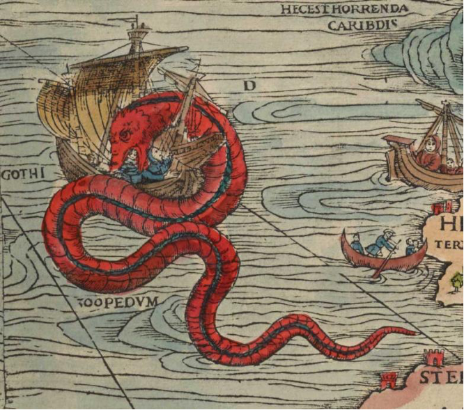
Figure 11, Olaus Magnus’ Map of Scandinavia, 1539, ‘Sea Orm’, James Ford Bell Library, University of Minnesota.

Figure 12, ‘Oarfish Skeleton’, 1981, The Natural History Museum, London, United Kingdom.
Another distinctive creature on the map is the Great Norwegian Serpent (Sea Orm) wrapping itself around the body of a large boat (figure 11). These sea serpents have a long history of reports and illustrations dating back to antiquity. There is also a tradition that sea orms are an omen of disaster or death. Oliver Crimmen (Senior Curator of fish at The Natural History Museum) states that these animals were in fact oarfish (Regalecus Glesne) which grow up to eight meters in length. These sea creatures normally dwell at 200-1000 meters below the sea and are only seen higher up when in distress[88] (figure 12). This point is rather important in understanding mankind’s understanding of the ocean during the Renaissance, it would not be uncommon for sea animals’ mangled carcass to wash up on shaw, nor for sailors to come across dead animals floating at sea.[89] Not only would seeing the bodies of such creatures have likely caused fear and astonishment. In fact Rev.Fr. Magnus’ map possibly depicts just such an event (figure 13). To see that even scary sea animals had pray, dead animals at sea often will have been munched on by other sea animals either before or after death, must have been unsettling, leading sailors to wonder what else lay in wait in the oceans.

Figure 13, Olaus Magnus, 1539, ‘Beached Whale’, Olaus Magnus’ Map of Scandinavia, James Ford Bell Library, University of Minnesota.
The Sea Orm was vividly described to Rev.Fr. Magnus by Nordic sailors and fishermen during his travels around Scandinavia. ‘A Compendious History of The Goths, Swedes & Vandals and Other Northern Nations’ (1658) quotes Rev.Fr. Magnus description of the Sea Orm as follows:
“They who in worked of navigation, on the Coast of Norway, employ themselves in fishing or merchants, do all agree in this strange story, that there is a serpent there which is of a vast magnitude, namely 200 foot long, and more – over 20 feet thick; and is wont to live in rocks and caves toward the sea-coast about berge: which will go alone from his holes in a clear night, in summer, and devour calves, lambs and hogs, or else he goes into the sea to feed on Polypus (octopus), Locusts (lobsters), and all sorts of sea-crabs. He hath commonly hair hanging from his neck a cubit long, and sharp scales, and is black, and he hath flaming shining eyes. This snake disquiets the shippers, and he puts up his head on high like a pilar, and catcheth away men, and he devours them; and this hapeth not, but it signifies some wonderful change of the Kingdom near at hand; namely that thr Princes shall die, or be banished; or some tumultuous wars shall presently follow.”[90]
Rev.Fr. Magnus captures the sea orm devouring a human on a ship whilst his shipmate seems to cry for help, there are men in rowing boats desperately trying to get to shaw and worried looking sailors in a vessel looking on at the carnage. The scene is one of chaos, chaos caused by the bright red swirling Sea Orm. The colour red seems to be strategically chosen by Rev.Fr. Magnus to indicate dangerous monsters, and this creature being the only bright solid red monster on his map may indicate that this is the most dangerous creature in his map. It might be no coincidence that Rev.Fr. Magnus chose to place this harbinger of doom next to the Kingdom of Norway,[91] as in 1536, only a few years before Magnus’s maps publication, the country adopted the Protestant faith.[92]
Rev.Fr. Magnus’s map contains many sea creatures he identifies as belonging to the whale family. He describes and depicts whales as being so large that their bodies could rise above a ship’s mast and spew clouds of water from their heads that could sink ships. One can understand where such a notion might have come from. Whales can reach stunningly large proportions and can spray water from their blowhole. If one did not understand a whale, it could be assumed that these sprays were a defence or attack mechanism.
Pristers—today scholars believe that this animal was in actual fact a sperm whale—are described by Rev.Fr. Magnus as being 300 feet long and very cruel animals. Two Pristers, (figure 14) on Rev.Fr. Magnus’ map, are shown chasing a Danish ship across the waves. Barrels float in the ship’s wake, thrown overboard to distract the beast, whilst a man onboard plays sharp notes from a trumpet, something Pristers apparently hate. According to Orkney Museums this story likely comes from folktales of Lofoten[93] in Arctic Norway, Shetland and Orkney.[94]
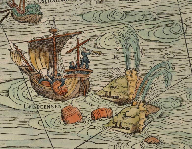
Figure 14, Olaus Magnus’ Map of Scandinavia, 1539, ‘Two Pristers Chasing a Ship’, James Ford Bell Library, University of Minnesota.

Figure 15, Unknown German, Jonah and the Whale, 15th Century, The Minnich Collection, Minneapolis Institute of Art Collection, Minneapolis, U.S.A.
Off the shore of Tile a Balena (figure 16), another whale is shown suckling’s its calf whilst being attacked by an orca. Again the whale is shown with water spewing fourth from two extended horn like blow holes. Each of Rev.Fr. Magnus whales share a degree of anatomical cohesiveness, something that would be expected from a species of animal, two blow holes, spikey crenulations and boar like snouts and tusks. Despite Rev.Fr. Magnus’ travels around Scandinavia he seems to have either never seen a whale, only ever seen one from afar, or perhaps even knew what a whale looks like but chose to depict it in a Renaissance fashion. If so then this could possibly have been because using current and pre-existing visual language would allow easier identification by viewers (figure 15).
During the 16th century pork was a luxury food stuff and therefore a symbol of wealth and indulgence. One of Martin Luther’s (1483-1546) grievances with the Catholic Church was that he viewed it as perpetrating the sin of gluttony (Fordham Honours Program, Date Unknown). He wrote that:
“Germany is a land of hogs and filthy people which debauches its body and its life. If you were going to paint it, you would have to paint a pig.”[95]
It could be possible that Rev.Fr. Magnus’ regular references to sea creatures looking like swine might be another jibe at the Lutheran church. After all this map was published in the center of Renaissance Europe, Italy, with Vatican support. It therefore makes sense that the visual style and political leanings would stay true to the art and outlook of Renaissance Italy.

Figure 16, Olaus Magnus’ Map of Scandinavia, 1539, ‘A Balena and its calf being attacked by an orca ’, James Ford Bell Library, University of Minnesota.
Not all sea creatures are described and depicted by Rev.Fr. Magnus was dangerous. Upon his map is a Rockas (figure 17), a type of stingray that protects humans from the devouring jaws of “dog fish”. Dog fish were unsettling and described by Rev.Fr. Magnus as:
“…he will eat his more tender parts, as the nostrils, fingers, privates, until such time as the Ray comes to revenge these injuries, which runs throw the waters armed with her natural fins & with some violence drives away these fish that set upon the drowned (soaked) man, and doth what he can to urge him to swim out.”[96]

Figure 17, Olaus Magnus’ Map of Scandinavia, 1539, ‘Rockas saving a man from sea-dogs ’, James Ford Bell Library, University of Minnesota.
Stingrays are known for their relatively friendly nature towards humans (Deep Sea World, Scotland’s National Aquarium, Date Unknown), so it makes sense that they would take on this protective role in early understanding of the ocean. Rev.Fr. Magnus’ rendering of the Rockas shows it grabbing hold of one of the four “dog fish” attacking a man. The swimmer is helpless, his vulnerability is emphasised by his nakedness, and there is nothing but the Rockas to protect him. The man is close to the shore and has no ship near to him, so seems to be simply a man from land who has gone for a ‘dip’ in the ocean or a fishman of some kind. This is also one of only two non-sailor interactions with sea monsters in Rev.Fr. Magnus’ map. The Rockas’ face is a friendly one, unlike other sea monsters on this map, it has no trace of red upon its form, has an open eye and a subtle smile across its mouth, all of which makes its large form seem protective rather than intimidating.
The fear of being dragged under the water and drowned is present in much of Rev.Fr. Magnus’ maps oceanic depictions. To be devoured by the sea or that which dwelled within it was a real fear. Many of these creatures, that today we regard as fanciful, played upon and represented very real worries of seafarers and landlubbers. One could also suggest that in a sense these monsters represented a respect for the bravery of sailors, many of the images on Rev.Fr. Magnus’ map show sailors' battles with these creatures in the face of almost certain death. In fact, the Renaissance period saw the publication and popularity of chivalric and romantic stories written about the great adventures and wealth gained by seafarers.[97] [98] [99]
Rev.Fr. Magnus’ map captured and preserved beliefs and systems of understanding that have almost completely disappeared from the European world, providing us with an important cultural time capsule. Fictitious animals on 16th and early 17th century maps hint at how people’s perception of and relationship with the ocean have changed over time.[100] Many of the maps contain references and inspirations from texts that are no longer in existence and therefore hold elements of human knowledge which are now lost to us.[101] In the case of Rev.Fr. Magnus’ map, it shows us the Scandinavia that he knew, a pre-reformation Scandinavia with much of its pre-Christian history intact in the memory of its people.
Various rationales have been put forth as to why Rev.Fr. Magnus created this map. However, two that I have not seen mentioned are the following. Firstly, the fact that Catholics were no longer welcome in a number of Scandinavian countries might have meant that Rev.Fr. Magnus was encouraged to make his map by his peers. People from within the church could no longer map the region but Rev.Fr. Magnus was well positioned to do so.
However, the theory that I proffer as being the most interesting is that because Rev.Fr. Magnus was no longer able to return to his homeland, he was motivated to create a map rich in cultural detail due to homesickness, or a wish to record what he remembered about his homeland for posterity. At a time before photography, might this map have functioned as his own personal visual memory? The fact that the map and its accompanying literature are so very densely packed with storytelling, information and illustration, is testament to the great amount of time and effort that Rev.Fr. Magnus laboured on this project, and thus the care he had for it.
Conclusion:
Maps and Monsters: Why and how did sea monsters find their way into the art of cartography?
Early Map-makers like Rev.Fr. Magnus’ included images of monsters on their maps of the oceans for more than a single reason. Illustrated maps stood out from the “crowd” thereby drawing in a higher price for their creation and prestige for their creator.
Such maps also built upon and drew from a lineage of illustrated maps and present to the modern day viewer a history of mankind’s relationship with the ocean. These maps are valuable for understanding a world that we no longer belong to but which has had great influence upon todays culture, particularly in regards to the arts, for example monsters in film and literature.
These maps are built upon and preserve memories from multiple generations and deserve greater recognition in this regards.
[1] D.V Duzer, Sea Monsters on Medieval and Renaissance Maps, (The British Library, 2013), p.81.
[2] The Rest is History, 306: Columbus: The Adventure Begins, (20th February 2023), Available at: Spotify, (Accessed:05/03/2024).
[3] M. Swift, Mapping The World, United Kingdom, (Chartwell Books, INC. 2006), p.14.
[4] Swift, Mapping The World, United Kingdom, p.14.
[5] D.Turnbull, Cartography and Science in Early Modern Europe: Mapping the Construction of Knowledge Spaces, Imago Mundi, 1996, Vol. 48. (1996), p.16.
[6] L. McEwen, The Art of Cartography: Cartes-a-Figures, Special Collections and Archives, Missouri Library, University of Missouri, (2021), Available at: https://library.missouri.edu/specialcollections/exhibits/show/the-art-of-cartography/ortelius (accessed: 31/12/2023).
[7] Duzer, Sea Monsters on Medieval and Renaissance Maps, p.16.
[8] Duzer, Sea Monsters on Medieval and Renaissance Maps, p.9.
[9] Duzer, Sea Monsters on Medieval and Renaissance Maps, p.12.
[10] C.C. Kappler, (1999), p.115 cited in Bobaru, Sea Monsters. Theoretical Perspectives, p.2.
[11] N. Bobaru, Sea Monsters. Theoretical Perspectives, (2022), DOI:10.47743/aic-2022-1-0001, (Accessed: 24/01/2024), p.1.
[12] Bobaru, Sea Monsters. Theoretical Perspectives, p.1.
[13] H. Waters, The Enchanting Sea Monsters on Medieval Maps, Smithsonian Magazine, (2013), https://www.smithsonianmag.com/science-nature/the-enchanting-sea-monsters-on-medieval-maps-1805646/, (Accessed: 30/12/2023).
[14] D. Brownstein, Reviewed Work (s): Sea Monsters on Medieval and Renaissance Maps by Van Duzer, Renaissance Quarterly, Vol. 68, No. 3., (2025), p.1029.
[15] Bobaru, Sea Monsters. Theoretical Perspectives, p.2.
[16] M. Swift, Mapping The World, (Chartwell Books, INC, 2006), p.14.
[17] C. Fairclough, From Mermaids to Manatees: the Myth and the Reality, Atlas Obscura, (2016), https://ocean.si.edu/ocean-life/marine-mammals/mermaids-manatees-myth-and-reality (Accessed: 10/01/2024)
[18] Kappler, 1999, p.196 cited in Bobaru, Sea Monsters. Theoretical Perspectives, p.2.
[19] Kappler, 1999, p.196 in cited in Bobaru, Sea Monsters. Theoretical Perspectives, p.2.
[20] Pliny The Elder, Translated by Bostock, J., Pliny The Elder, Natural History, (Date Unknown), Available at : https://www.perseus.tufts.edu/hopper/text?doc=Plin.+Nat.+toc, (Accessed: 18/01/2024).
[21] Waters, The Enchanting Sea Monsters on Medieval Maps, Smithsonian Magazine.
[22] Duzer, Sea Monsters on Medieval and Renaissance Maps, p.8.
[23] Bobaru, Sea Monsters. Theoretical Perspectives, pp.2-3.
[24] Many of the sea animals, such as whales and walruses, were considered to be monsters during the Renaissance period (Sea Monsters on Medieval and Renaissance Maps, p.8). Due to lower levels of fishing during earlier centuries, it is possible that people encountered sea creatures with a far more imposing stature then those that now swim the oceans. This combined with the awe-inspiring nature of the appearance of these animals, regardless of size, makes it no wonder that they would have been understood as ‘monster like’ (The Library of Congress).
[25] Brownstein, Reviewed Work (s): Sea Monsters on Medieval and Renaissance Maps by Van Duzer, p.1030.
[26] Bobaru, Sea Monsters. Theoretical Perspectives, p.3.
[27] Bobaru, Sea Monsters. Theoretical Perspectives, p.1-3.
[28] Prior to the creation of land, vegetation, animals and man existed in the abyss. It was dark and without land, only endless water with wind sweeping over its surface (Bible, (Unknown), https://www.usccb.org/, (Accessed: 01/01/2024), Psalm 2).
[29] Bible, Psalm, 11 & 21-22.
[30] Corbin, 1988: 12, cited in Bobaru, , Sea Monsters. Theoretical Perspectives, p.1.
[31] Brownstein, Reviewed Work (s): Sea Monsters on Medieval and Renaissance Maps by Van Duzer, p.1030.
[32] Brownstein, Reviewed Work (s): Sea Monsters on Medieval and Renaissance Maps by Van Duzer, p.1029.
[33] Duzer, Sea Monsters on Medieval and Renaissance Maps, p.12.
[34] Duzer, Sea Monsters on Medieval and Renaissance Maps, p.11.
[35] Completing such training was a scholarly as well as religious process, attracting those who had received a calling or were learned men. The latter is easy to understand as higher education did not exist the way it does today and that many of the oldest universities in Europe were formally monasteries or seminaries. In fact, it was not unusual for priests to become well respected scholars in various subjects (L.O. Kattsoff, The Priesthood of The Scholar, The Christian Scholar, Vol. 39, No. 3, (September 1956), Pen State University Press, (Accessed: 11/03/2024), p.169 & The Origin of Universities, Unknown), Rev.Fr. Magnus and his brother were examples of this.
[36] Finebooks & Collections, Cartographer Olaus Magnus’ Map of Sea Monsters, Finebooks & Collections, (2022), 2022), https://www.finebooksmagazine.com/issue/cartographer-olaus-magnus-map-sea-monsters (Accessed: 24/01/2024).
[37] E. Thompson, The Sea Monsters of Olaus Magnus: Classifying Wonder in the Natural World of Sixteenth Century Europe, The Portolan Issue 81, Washington Map Society, (2011).
[38] Rev.Fr. Magnus’ brother, Johannes Magnus (1488-1544) was also a historian, genealogist and historian.
[39] After the death of his brother Archbishop Johannes Magnus (1488-1544) in 1544 Rev.Fr. Magnus was made Archbishop of Uppsala in his place (Finebooks & Collections, Cartographer Olaus Magnus’ Map of Sea Monsters).
[40] Finebooks & Collections, Cartographer Olaus Magnus’ Map of Sea Monsters.
[41] E. Sandmo, Olaus Magnus and The Epistemologies of The Renaissance, Max Planck Institute for The History of Science, (2013-2014), https://www.mpiwg-berlin.mpg.de/research/projects/DeptII_Sandmo_OlausMagnus, (Accessed: 05/03/2024).
[42] Danzig was the largest city in Poland from the 15th-17th century.
[43] E. Schnayder, Bernhard Wapowski’s Lost Maps of Poland, Sarmatias and Scandinavia, Imago Mundi, 26, (1972), Jstor: 1150648, (Accessed: 11/02/2024), pp.76-77.
[44] Finebooks & Collections, Cartographer Olaus Magnus’ Map of Sea Monsters.
[45] Bernard Wapowski (1450-1535) is credited with making the first detailed map of Poland in 1526 (E. Schnayder, Bernhard Wapowski’s Lost Maps of Poland, Sarmatias and Scandinavia, pp.76-77).
[46] Orkney Museums, The Carta Marina of Olaus Magnus, 1539, Orkney Museums, https://www.orkneymuseums.co.uk/the-carta-marina-of-olaus-magnus-1539/, (Unavailable), (Accessed:22/01/2024).
[47] Orkney Museums, The Carta Marina of Olaus Magnus.
[48] University of Minnesota Libraries, James Ford Bell Library, University of Minnesota, (2014), https://gallery.lib.umn.edu/exhibits/show/olausmagnus/olausmagnus, (Accessed:22/01/2024).
[49] University of Minnesota Libraries.
[50] University of Minnesota Libraries.
[51] Finebooks & Collections, Cartographer Olaus Magnus’ Map of Sea Monsters.
[52] These reside in the Bavarian State Library, Munich Germany & Uppsala University Library, Uppsala, Sweden.
[53] Finebooks & Collections, Cartographer Olaus Magnus’ Map of Sea Monsters.
[54] Orkney Museums, The Carta Marina of Olaus Magnus.
[55] For example, Thomas Berg suggests that one illustration, depicting two armies facing off over an ice gulf off Finland, is referencing the Muscovites attempt to conquer Viborg by riding over the ice in 1495 (Finebooks & Collections, 2022).
[56] Finebooks & Collections, Cartographer Olaus Magnus’ Map of Sea Monsters.
[57] Finebooks & Collections, Cartographer Olaus Magnus’ Map of Sea Monsters.
[58] Orkney Museums, The Carta Marina of Olaus Magnus.
[59] Orkney Museums, The Carta Marina of Olaus Magnus.
[60] Finebooks & Collections, Cartographer Olaus Magnus’ Map of Sea Monsters.
[61] Finebooks & Collections, Cartographer Olaus Magnus’ Map of Sea Monsters.
[62] Duzer, Sea Monsters on Medieval and Renaissance Maps, p.85.
[63] The inclusion of certain animals as a reaction to Protestantism potentially discredits Luigi de Anna’s (Historian, b.1946) suggestion that the monsters were included by Rev.Fr. Magnus with the intention of scaring away foreign fishermen, thereby encouraging Scandinavian fishermen with a fishing monopoly (Duzer, Sea Monsters on Medieval and Renaissance Maps, pp. 86 & 11). If Luigi de Anna was correct then the presence of sea monsters would have had an unusual economic function not shared by other maps (Duzer, Sea Monsters on Medieval and Renaissance Maps, p.86), which usually aided in finding economic prosperity and not in scaring others away from it.
[64] Carol Urness (University of Minnesota Library), argues that the map was made for and used by navigators. However, it is unlikely that someone would pay to have such an expensive, large, lavishly decorated and coloured map for a sea voyage where all manner of things might happen to it (Finebooks & Collections). The fact that this map has rhum lines[64] might have been the reason for Urness’ conclusion, however it seems more probable that such a decadent map was published with the parlours of the mercantile class in mind (Finebooks & Collections).
[65] Because there was less knowledge about the oceans contents and greater religious adherence, the terrifying monsters seen in Rev.Fr. Magnus’ map might have been seen as real. However, Renaissance Europe witnessed scientific fervour and questioning of religious doctrine which meant that maps like Rev.Fr. Magnus’ might have been seen as purely an artistic exercise or as a record of older thoughts about the oceans.
[66] Bible, Psalm 104:25-26.
[67] U. Banerji, ‘Can You Spot All The Sea Monsters in This 16th Century Map?’, Atlas Obscura, 2016, https://www.atlasobscura.com/articles/can-you-spot-all-the-sea-monsters-in-this-16thcentury-map, (Accessed on the 3/01/2024).
[68] Orkney Museums, The Carta Marina of Olaus Magnus.
[69] Duzer, Sea Monsters on Medieval and Renaissance Maps, p.86.
[70] University of Minnesota Libraries.
[71] University of Minnesota Libraries.
[72] Finebooks & Collections, Cartographer Olaus Magnus’ Map of Sea Monsters.
[73] R. Karrow, Mapmakers of The Sixteenth Century and Their Maps, (Speculum Obris, 1993), p.363.
[74] J. Dalton J., The Rise and Fall of Swedish Catholicism, (2020), https://catholicherald.co.uk/the-rise-and-fall-of-swedish-catholicism/, (Accessed:05/03/2024).
Deep Sea World, Scotland’s National Aquarium, (Date Unknown), A Common Stingray Called Stella, Available at:https://www.deepseaworld.com/discover/animals/common-stingray/, Accessed: (01/01/2024)
[75] The Hortus Sanitatis was a Latin encyclopaedia on Natural History which included descriptions of the natural world and their medical uses written by Jacob Meydenbach in 23 June 1491.
[76] Duzer, Sea Monsters on Medieval and Renaissance Maps, p.83.
[77] Icelandic texts describe these animals as exuding a scent that attracts fishes to its jaws. Today this is called ‘trap feeding’ which points toward Icelandic ‘The Whale Island’ being in actual fact a Humpback Whale.
[78] Unknown, The Hrafnista Sagas, Translated by Waggoner B., U.S.A., 2012, pp. xxvii-xxviii.
[79] G. Constantino, G., Five “Real” Sea Monsters Brought to Life by Early Naturalists, (2014), https://www.smithsonianmag.com/science-nature/five-real-sea-monsters-brought-life-early-naturalists-180953155/#:~:text=Magnus%20identified%20these%20beasts%20as,water%20cannons%20drowning%20unlucky%20vessels, (Accessed: 05/03/2024).
[80] Finebooks & Collections, Cartographer Olaus Magnus’ Map of Sea Monsters.
[81] University of Minnesota Libraries.
[82] Thompson, The Sea Monsters of Olaus Magnus: Classifying Wonder in the Natural World of Sixteenth Century Europe.
[83] Duzer, Sea Monsters on Medieval and Renaissance Maps, pp.81-82.
[84] Brownstein, Reviewed Work (s): Sea Monsters on Medieval and Renaissance Maps by Van Duzer, pp.1029-1030
[85] Finebooks & Collections, Cartographer Olaus Magnus’ Map of Sea Monsters.
[86] Brownstein, Reviewed Work (s): Sea Monsters on Medieval and Renaissance Maps by Van Duzer, pp.1029-1030
[87] Duzer, Sea Monsters on Medieval and Renaissance Maps, p.86.
[88] K.Lotzof, Sea Monsters and Their Inspirations: Serpents Mermaids, The Kraken and More, (Date Unknown), https://www.nhm.ac.uk/discover/sea-monsters-inspiration-serpents-mermaids-the-kraken.html, (Accessed: 01/02/2024).
[89] Costantino, Five “Real” Sea Monsters Brought to Life by Early Naturalists, 2014.
[90] J. Nigg, Olaus Magnus’ Sea Serpent, The Public Domain Review, 2014, (https://publicdomainreview.org/essay/olaus-magnus-sea-serpent/#p-3-1), (Accessed: 01/02/2024).
[91] Effectively a colony of Denmark at the time of Magnus’ map’s publication.
[92] World Council of Churches, Church of Norway, (Date Unknown), https://www.oikoumene.org/member-churches/church-of-norway, (Accessed: 01/03/2024)
[93] The Lofoten Islands are located far off the North of Norway and have been long thought of as a haunt of trolls and the Valkyries. These Island’s waters were popular with various marine life and therefore also became an important stop of point for Vikings to stock up on provisions for voyages. Such abundant waters makes it no wonder that tales of extraordinary sea creatures were told by sailors that made their way across its waters.
[94] Orkney Museums, The Carta Marina of Olaus Magnus.
[95] (Martin Luther quoted in Fordham Honours Program, Date Unknown).
[96] Orkney Museums, The Carta Marina of Olaus Magnus.
[97] The Rest is History, 306: Columbus: The Adventure Begins, 20th February 2023, Spotify, (Accessed: 05/03/2024).
[98] The published accounts of the adventures of the Venetian merchant and explorer, Marco Polo (1254-1324), is an example of this (Polo, 2015).
[99] Rev.Fr. Magnus’ map became a source of iconography of sea monsters and of inspiration for other cartographers of Northern Lands(Finebooks & Collections, Cartographer Olaus Magnus’ Map of Sea Monsters). For example Abraham Ortelius’ (1527-1598), often credited with having created the first real “atlas” of the world, wrote that he had used Rev.Fr. Magnus’ map in creating his map of Scandinavia for his atlas (1570) (University of Minnesota Libraries). The margins of his 1564 engraved wall map of Europe were filled with creatures visibly influenced by Rev.Fr. Magnus’ work (Brownstein, 2015, pp.1029-1030). Sebastian Munster’s Cosmographic; Beschreibung aller Lender (Cosmography; A Description of all lands) published in 1544 (University of Minnesota Libraries even contains a plate with sea beasts from the Western half and land-based mammals from the Eastern half of Rev.Fr. Magnus’ map (Finebooks & Collections, 2022).
[100] Waters, The Enchanting Sea Monsters on Medieval Maps, Smithsonian Magazine.
[101] Duzer, Sea Monsters on Medieval and Renaissance Maps, p.8.
Bibliography:
Articles:
Banerji, U, ‘Can You Spot All The Sea Monsters in This 16th Century Map?’, Atlas Obscura, 2016, Available at: https://www.atlasobscura.com/articles/can-you-spot-all-the-sea-monsters-in-this-16thcentury-map, (Accessed on the 3/01/2024).
British Museum, Available at: https://www.britishmuseum.org/collection/object/A_As1942-01-1
Brownstein, D., ‘Reviewed Work (s): Sea Monsters on Medieval and Renaissance Maps by Van Duzer’, Renaissance Quarterly, Vol. 68, No. 3., 2025.
Davies, S., Renaissance Ethnography and the Invention of the Human: New Worlds, Maps and Monsters, Cambridge University Press, 2016, (Accessed: 30/12/2023).
Fairclough, C., ‘From Mermaids to Manatees: the Myth and the Reality’, Atlas Obscura, 2016, Available at: https://ocean.si.edu/ocean-life/marine-mammals/mermaids-manatees-myth-and-reality (Accessed 10/01/2024).
Finebooks & Collections, ‘Cartographer Olaus Magnus’ Map of Sea Monsters’, Finebooks & Collections, 2022, Available at: https://www.finebooksmagazine.com/issue/cartographer-olaus-magnus-map-sea-monsters (Accessed: 24/01/2024).
Fordham Honours Program, The Function and Connotation of Swine in the 16th Century), (Date Unknown), Available at: https://emh30.ace.fordham.edu/2018/12/10/the-function-and-connotation-of-swine-in-the-sixteenth-century/, (Accessed: 21/01/2023).
Kattsoff, L.O., The Priesthood of The Scholar, The Christian Scholar, Vol. 39, No. 3, September 1956, Pen State University Press, 1956, (Accessed: 11/03/2024).
Maclear K., Artist Shaun Tan Makes The Familiar Strange, Orion Magazine, Date Unknown, Available at: https://orionmagazine.org/article/shaun-tan-artist-interview/, Accessed:21/02/2024).
McEwen, L., ‘The Art of Cartography: Cartes-a-Figures’, Special Collections and Archives, Missouri Library, University of Missouri, 2021, Available at: https://library.missouri.edu/specialcollections/exhibits/show/the-art-of-cartography/ortelius (accessed: 31/12/2023).
Nigg J., ‘Olaus Magnus’ Sea Serpent’, The Public Domain Review, 2014, Available at: https://publicdomainreview.org/essay/olaus-magnus-sea-serpent/#p-3-1, Accessed: (01/02/2024).
Orkney Museums (Unavailable), ‘The Carta Marina of Olaus Magnus, 1539’, Orkney Museums, Available at: https://www.orkneymuseums.co.uk/the-carta-marina-of-olaus-magnus-1539/ (Accessed:22/01/2024).
Sandmo E., Olaus Magnus and The Epistemologies of The Renaissance, Max Planck Institute for The History of Science, 2013-2014, Accessed at: https://www.mpiwg-berlin.mpg.de/research/projects/DeptII_Sandmo_OlausMagnus, Accessed: (05/03/2024).
Schnayder, E., Bernhard Wapowski’s Lost Maps of Poland, Sarmatias and Scandinavia, Imago Mundi, 26, 1972, Jstor: 1150648, (Accessed: 11/02/2024).
The Library of Congress, ‘Imaginary Maps in Literature and Beyond: Map Monsters’, 2016, Available at: https://blogs.loc.gov/maps/2016/08/imaginary-maps-in-literature-and-beyond-map-monsters/
Van Duzer, D., Sea Monsters on Medieval and Renaissance Maps, The British Library, United Kingdom, 2013.
Thompson, E., ‘The Sea Monsters of Olaus Magnus: Classifying Wonder in the Natural World of Sixteenth Century Europe’, The Portolan Issue 81, Washington Map Society, 2011.
Turnbull, D., ‘Cartography and Science in Early Modern Europe: Mapping the Construction of Knowledge Spaces’, Imago Mundi, 1996, Vol. 48., 1996.
Turner, E.J., ‘A Very Little History of Mermaid Hoaxes, 2016, Available at: https://emilyjessicaturner.com/2016/06/02/a-very-little-history-of-mermaid-hoaxes/
University of Minnesota Libraries (2014), James Ford Bell Library, University of Minnesota, Available at: https://gallery.lib.umn.edu/exhibits/show/olausmagnus/olausmagnus,
(Accessed:22/01/2024).
Waters, H, ‘The Enchanting Sea Monsters on Medieval Maps’, Smithsonian Magazine, Available at: https://www.smithsonianmag.com/science-nature/the-enchanting-sea-monsters-on-medieval-maps-1805646/, (Accessed: 30/12/2023).
Books:
Bobaru, N., Sea Monsters. Theoretical Perspectives, 2022, DOI:10.47743/aic-2022-1-0001, (accessed: 24/01/2024).
Heaney, S., Beowulf, Faver & Faber Limited, United Kingdom, 2000.
Karrow, R., Mapmakers of The Sixteenth Century and Their Maps, Speculum Obris, Illinois U.S.A., 1993.
Lotzof K., Sea Monsters and Their Inspirations: Serpents Mermaids, The Kraken and More, Date Unknown, Available at: https://www.nhm.ac.uk/discover/sea-monsters-inspiration-serpents-mermaids-the-kraken.html, (Accessed: 01/02/2024).
Magnus, O., Historia de Gentibus Septentrionalibus, 1555.
Pliny The Elder, Translated by Bostock, J., Pliny The Elder, Natural History, Date Unknown, Available at : https://www.perseus.tufts.edu/hopper/text?doc=Plin.+Nat.+toc, (Accessed: 18/01/2024).
Polo, M., The Travels: Marco Polo, Penguin Classics; Illustrated Editions, United Kingdom, 2015.
Swift, M., Mapping The World, United Kingdom, Chartwell Books, INC, 2006.
Unknown, The Hrafnista Sagas, Translated by Waggoner B., U.S.A., 2012.
Websites:
Bible, Unknown, Available at: https://www.usccb.org/, (Accessed: 01/01/2024).
Constantino, G., Five “Real” Sea Monsters Brought to Life by Early Naturalists, 2014, Available at: https://www.smithsonianmag.com/science-nature/five-real-sea-monsters-brought-life-early-naturalists-180953155/#:~:text=Magnus%20identified%20these%20beasts%20as,water%20cannons%20drowning%20unlucky%20vessels, (Accessed: 05/03/2024).
Dalton J., The Rise and Fall of Swedish Catholicism, 2020, Available at: https://catholicherald.co.uk/the-rise-and-fall-of-swedish-catholicism/, (Accessed: 05/03/2024).
Deep Sea World, Scotland’s National Aquarium, (Date Unknown), A Common Stingray Called Stella, Available at:https://www.deepseaworld.com/discover/animals/common-stingray/, (Accessed: 01/01/2024).
Stockholms Katolska Stift Dioecesis Holmiensis, The History of The Catholic Church in Sweden, Date Unknown, Available at: https://www.katolskakyrkan.se/cardinal-anders-arborelius/the-history-of-the-catholic-church-in-sweden#:~:text=Gustav%20III's%20Edict%20of%20Tolerance,an%20Apostolic%20Vicariate%20in%20Sweden, (Accessed: 30/12/2023).
The Library of Congress, 2016, Available at: https://www.loc.gov/, (Accessed: 01/02/2024)
The Origin of Universities, The University of Texas, Austin, Available at: https://www.utexas.edu/about/history, (Accessed: 11/03/2024).
World Council of Churches, Church of Norway, Date Unknown, Available at: https://www.oikoumene.org/member-churches/church-of-norway, (Accessed: 01/03/2024)
Podcast:
The Rest is History, 306: Columbus: The Adventure Begins, 20th February 2023, Available at: Spotify, Accessed: (05/03/2024).